

In its latest hourly update on the landfall of Cyclone Montha ('fragrant flower' in Thai), the IMD (India Meteorological Department) stated that the severe cyclonic storm moved north-northwestwards and at 3.30 pm today, 28 October, and lay about 60 km south-southeast of Machilipatnam, 140 km south-southeast of Kakinada (Andhra Pradesh), 240 km south-southwest of Visakhapatnam (Andhra Pradesh), and 480 km south-southwest of Gopalpur (Odisha).
It is expected to cross the Andhra Pradesh coast between Machilipatnam and Kalingapatnam around Kakinada during evening or night today as a severe cyclonic storm, with maximum sustained wind speed of 90–100 kmph gusting to 110 kmph.
“The SCS Montha moved north-northwestwards and is likely to cross the Andhra Pradesh coast around Kakinada during the evening or night of 28 October as a severe cyclonic storm, with maximum sustained wind speed of 90–100 kmph gusting to 110 kmph,” the IMD said on X.
HOURLY UPDATE BASED ON 1530 HOURS IST OF 28TH OCTOBER 2025 FOR SCS “MONTHA”
— India Meteorological Department (@Indiametdept) October 28, 2025
The SCS Montha moved north-northwestwards and at 1530 hrs IST of 28th Oct, it lay about 60 km south-southeast of Machilipatnam, 140km south-southeast of Kakinada (Andhra Pradesh), 240 km south-southwest… pic.twitter.com/eiTgiuDRDB
As a precaution, all 32 flights operating from Visakhapatnam Airport were cancelled on Tuesday. “Actually, we are operating 30 to 32 movements daily, both domestic and international. Today, all those flights are cancelled,” Visakhapatnam Airport director N. Purushottam told PTI, adding that the airport has implemented Airports Authority of India (AAI) cyclone protocols, covering pre- and post-storm safety phases.
At Vijayawada Airport, 16 flights were cancelled, though five managed to operate, airport director Lakshmikanth Reddy said. “The airlines have taken a decision to suspend operations for today. Clarity on tomorrow’s flights may emerge by evening,” he added.
Heavy rain, strong winds batter Kerala; fisherman dies off Alappuzha coast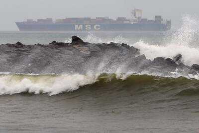

According to the IMD, extremely heavy rainfall — of 21 cm or more in 24 hours — was recorded at isolated places over coastal Andhra Pradesh and Yanam, while heavy rainfall (7–11 cm) occurred in Rayalaseema, Kerala, Mahe, Odisha, Chhattisgarh, East Madhya Pradesh, Madhya Maharashtra, and Tamil Nadu.
Several coastal towns reported waterlogging and power outages as authorities moved thousands of residents from low-lying areas to temporary shelters.
The IMD issued an orange alert for several Odisha districts, forecasting heavy to very heavy rainfall at isolated places in Nawarangpur, Kalahandi, Kandhamal, Nayagarh, Khordha and Puri. Surface winds reaching 50–60 kmph, gusting to 70 kmph, are likely in Ganjam, Kandhamal, Boudh, Bolangir, and Nuapada districts.
A yellow alert has been issued for Angul, Dhenkanal, Cuttack, Jagatsinghpur, Kendrapara, Jajpur, Keonjhar, Bhadrak, Balasore, Mayurbhanj, Sambalpur, Deogarh, Jharsuguda, Sundargarh, Sonepur, and Bargarh, with wind speeds expected to reach 40–50 kmph, gusting up to 60 kmph.
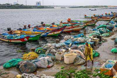
Authorities in both Andhra Pradesh and Odisha have deployed disaster response teams, and control rooms have been activated in all coastal districts. Fishermen have been advised not to venture into the sea until at least 29 October, with rough conditions expected to persist for 24 more hours post-landfall.
Officials said the cyclone would bring extremely heavy rainfall to northern coastal Andhra Pradesh and adjoining southern Odisha before gradually weakening as it moves inland.
You may also like

China blocks South Korean survey ship near West Sea structures in second standoff this year: Report
Union Minister Chirag Paswan welcomes second phase of SIR, says "necessary for robust democracy"
Vice President Radhakrishnan calls for hard work to fulfil 'Viksit Bharat 2047' vision
The 11 stunning 'haunted' UK places to visit by train on Halloween
Why can't Bihar have Muslim CM, questions Asaduddin Owaisi


